Boundary disputes are among the most emotionally charged — and financially ruinous — situations a homeowner can face. A disagreement over a few centimetres of land can escalate into years of litigation, tens of thousands of pounds in legal costs, and a permanent breakdown of neighbourly relations. As a building surveyor in East Sussex, I have been instructed as an expert witness and boundary expert in dozens of disputes, and the most common observation I can make is this: the overwhelming majority could have been resolved early, cheaply, and amicably with the right professional input at the outset.
This guide explains how property boundaries are established in England and Wales, what evidence matters, what a boundary surveyor's expert report contains, and — most importantly — how to resolve a boundary dispute without ending up in court.
How Property Boundaries Work in England and Wales
The first thing to understand is that the Land Registry title plan — the coloured map most people refer to when asked about their property boundary — does not define the precise legal boundary of your property. This surprises many homeowners. The title plan is drawn to a scale (typically 1:1250 for urban areas) that means even a thin line on the map represents 500mm on the ground. It shows the general extent of your registered title, not the exact boundary line.
The precise legal boundary is defined by the title deeds — the original conveyance documents and any subsequent transfers. These may contain detailed measurements, references to physical features (hedges, walls, fences), or express language about boundary ownership. Pre-1990s deeds in particular often contain meticulous hand-drawn plans with measured dimensions and verbal descriptions of boundary features.
Unfortunately, many deeds are vague, contradictory, or simply silent on the precise boundary location. This is where disputes arise — usually when one party builds or plants up to, or over, what they believe to be the boundary.
Common Causes of Boundary Disputes in East Sussex
In my experience across Crowborough, Tunbridge Wells, Uckfield, and the wider East Sussex area, the most common triggers for boundary disputes are:
- Fence replacement: A neighbour replaces a fence and positions it differently from the original — even by a few centimetres
- New development: A planning application or building work reveals an assumed boundary that differs from the legal boundary
- Hedge removal: When a boundary hedge is removed and replaced by a hard boundary, the exact position is disputed
- Adverse possession: One party claims to have occupied a strip of land for twelve or more years and applies to register title to it
- Extension or outbuilding: A new structure is built close to or on the assumed boundary
- New ownership: A property changes hands and the new owner disputes the accepted boundary position
What Evidence Determines a Boundary?
Establishing a boundary requires assembling and interpreting all available evidence. Here is the hierarchy of evidence that courts and the Land Registration Act recognise:
Original Conveyance Deeds
The most important document. The language, measurements, and plans in the original conveyance that created the current ownership structure define the intended boundary.
Physical Features at Date of Conveyance
The physical features that existed at the time of conveyance — walls, fences, hedges — and their precise positions, as they were at that date. Historical photographs and Ordnance Survey maps help establish this.
Ordnance Survey Maps
Historical OS maps showing the positions of physical features at different dates. Useful for establishing when features changed and what the position was at key dates.
Land Registry Title Plans
Indicative only, not conclusive. But useful as contextual evidence, particularly in identifying the general extent of registered titles.
Witness Evidence
Statements from long-standing neighbours, former owners, or others who recall the position of boundary features over time.
Aerial Photography
Historic aerial photographs — particularly from the 1940s–1970s — can show the position of hedges, fences and walls before any disputes arose.
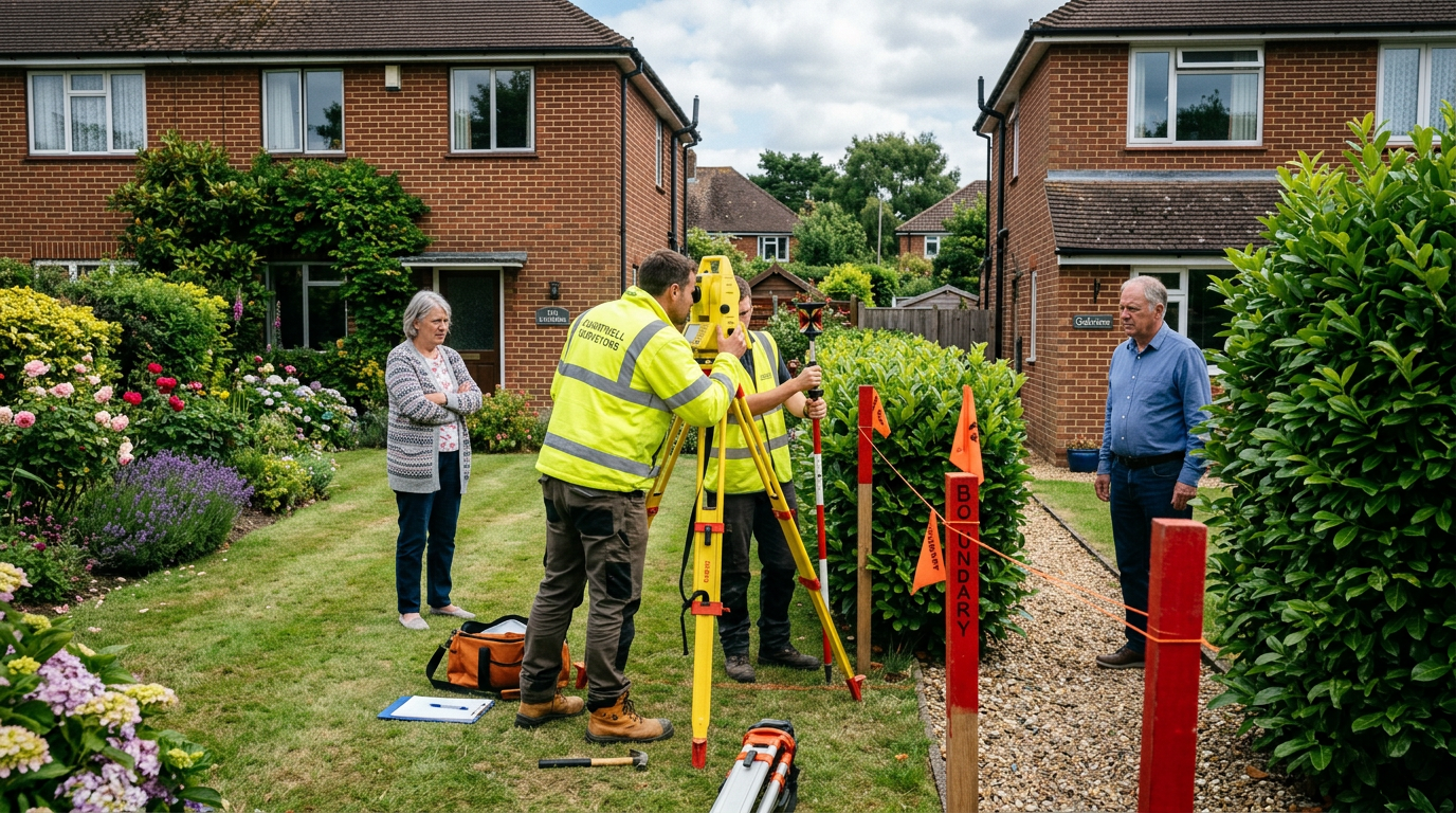
The Role of the Expert Boundary Surveyor
A boundary surveyor instructed as an expert witness performs a fundamentally different role from a surveyor carrying out a building survey. The boundary expert's job is to:
- Gather and interpret all available documentary, cartographic and physical evidence
- Carry out a precise measured survey of the site, locating all physical features accurately
- Compare the physical evidence against the documentary evidence
- Form an expert opinion as to the most probable position of the legal boundary
- Produce a formal expert report that can be used in negotiations, mediation, or court proceedings
The expert surveyor is required by the Civil Procedure Rules to owe their primary duty to the court — not to their instructing party. This means a good expert surveyor will give an honest opinion even if it is not what their client wanted to hear. An expert who simply argues their client's case regardless of the evidence will be quickly identified as partisan by any competent judge, and their evidence will be given little weight.
How to Resolve a Boundary Dispute Without Going to Court
Boundary litigation is extremely expensive — a fully contested boundary dispute before the Land Registration Adjudicator or in the county court can cost each side £30,000–£100,000 or more. The amount of land in dispute is usually worth far less than the legal costs. This is why early, professionally assisted resolution is almost always the right approach.
Commission a Boundary Report
Instruct an experienced surveyor to carry out a boundary investigation and produce a report. This gives you an objective picture of your position before spending money on lawyers.
Explore Direct Negotiation
With the boundary report in hand, approach your neighbour calmly and constructively. Share the evidence. In many cases, disputes arise from genuine misunderstanding rather than bad faith, and objective evidence resolves them.
Consider a Boundary Agreement
If there is genuine ambiguity, both parties may agree to formalise a mutually acceptable boundary position through a formal boundary agreement registered at the Land Registry. This is far cheaper than litigation and provides certainty for both parties.
Try Mediation
A professional mediator experienced in property disputes can help parties reach a negotiated settlement. Mediation is voluntary, confidential, and far less costly than court. Courts increasingly expect parties to have attempted mediation before issuing proceedings.
Formal Determination as Last Resort
If all else fails, the Land Registry's First-tier Tribunal (Property Chamber) can make a formal determination of the boundary. This is expensive, stressful and uncertain — genuinely a last resort.
Do Not Take Self-Help Action
Do not remove your neighbour's fence, re-erect your own fence on the disputed line, or take any physical action to assert your claimed boundary without legal advice. Such action can amount to trespass, conversion, or even criminal damage, and will severely prejudice your legal position if the matter proceeds to court. Always take professional advice before acting.
What If a Structure Has Been Built Over the Boundary?
Encroachment — where a building, extension, or structure physically crosses onto a neighbouring property — is a serious matter. If you discover that your neighbour's extension has been built partly on your land, or that your own building crosses the boundary, you have several options depending on the extent of the encroachment and the goodwill of the parties.
Minor encroachments of a few centimetres are often resolved through a deed of easement or formal licence granting the encroaching owner a right to maintain the structure. More significant encroachments may require physical remediation, substantial compensation, or a formal transfer of the land. The key is to act promptly — delay can strengthen an adverse possession claim and limit your remedies.
Frequently Asked Questions About Boundary Disputes
Who owns the boundary fence in a typical English property?
There is no universal rule — the title deeds determine boundary ownership. "T" marks on the title plan indicate ownership: the cross of the T is on the owner's side. If both sides have T marks (a "H" mark), both parties own the boundary feature jointly. Many deeds are silent on ownership, in which case the position of the physical feature (e.g. which side posts are on) provides evidence of intent.
Can the Land Registry determine my exact boundary?
The Land Registry can register a "determined boundary" under section 60 of the Land Registration Act 2002, but this is a formal process requiring detailed survey evidence and agreement between neighbours (or a tribunal determination in case of dispute). It is not a quick or cheap process, but it provides permanent certainty and removes the boundary from dispute.
How long does a boundary dispute take to resolve?
With goodwill and professional input, many boundary disputes are resolved within a few months. Contested litigation before the Land Registration Adjudicator or courts routinely takes two to four years. This is a powerful argument for attempting mediated resolution early — the longer a dispute continues, the higher the legal costs and the greater the personal stress on all involved.
What is adverse possession and does it apply to boundary strips?
Adverse possession ("squatter's rights") allows someone who has openly, continuously and exclusively occupied land for twelve years or more (10 years for registered land under the 2002 Act) to apply to register title to it. For registered land, the current process involves the Land Registry notifying the registered owner, who can then object. Applications are made to the Land Registration Adjudicator if disputed. Adverse possession claims relating to boundary strips are common and require careful professional analysis.
Do I need a solicitor or a surveyor for a boundary dispute?
Both, in most cases — but typically the surveyor first. A boundary surveyor gathers and interprets the physical and cartographic evidence and produces an expert report on the boundary position. The solicitor advises on your legal rights and options given that expert evidence. Starting with the surveyor is usually more cost-effective, as it clarifies your factual position before legal strategy is decided.
Act Early, Act Professionally
The most important advice I can give to anyone facing a boundary dispute in East Sussex is this: act early and seek professional advice before the dispute escalates. A boundary investigation and expert report commissioned early provides objective clarity, enables informed negotiation, and is far less expensive than months or years of contested litigation.
At Crowborough Surveyor, our experienced surveyors provide boundary investigation reports, expert witness services, and advice on boundary matters across East Sussex and Kent. Contact us for a confidential, no-obligation discussion.
Facing a Boundary Dispute?
Get expert, impartial advice from our surveyors in East Sussex. We help resolve disputes before they reach court.
Get a Free Consultation